Online Training Program | Lifetime Access
Registration is open
Understanding Urban Environment with GIS: Assessment & Modeling, of Environmental Impact
This is a comprehensive training program on exploring, modeling, and analyzing urban landscapes with advanced geospatial techniques.This course provides an in-depth exploration of urban environments through the use of advanced geospatial technologies. Tailored for researchers, urban planners, and GIS professionals, the program offers a comprehensive blend of theoretical understanding and practical experience. Participants will work with state-of-the-art tools like Google Earth Engine, ArcGIS, and Fragstat to perform land use and land cover classification, assess urban sprawl, and model urban growth patterns.
Throughout the course, participants will build expertise in image processing, accuracy assessments, and landscape metrics analysis, enabling them to accurately interpret urban dynamics and project future growth scenarios. Special attention is given to environmental impact assessments, focusing on urban heat islands, green space fragmentation, and the relationships between land use and environmental quality. By the end of the course, participants will be equipped with the skills and knowledge to apply geospatial technology for informed decision-making in urban planning and sustainable environmental management.
Are you interested in analyzing, modeling, and forecasting urban environmental changes using cutting-edge geospatial technology?
This thorough training course will provide you with the most recent tools and approaches for urban growth assessment, environmental impact research, and geospatial modelling, including Google Earth Engine, ArcGIS, TerrSet, Fragstat, and more!
📅 Course Details
📍 Mode: Online
🚀 Course Start Date: Immediate Access After Enrollment
Duration: 15 Sessions (Self-Paced)
📜 Certification: Provided upon completion🔗 Course Fee: Rs. 6500 / $75
Access: Lifetime Access
ABOUT Online Training Program
Course Outline
1. Exploration of the Urban Landscape
a. Land Use and Land Cover Classification
- Image Compositing, Enhancement, and Cloud Masking – Google Earth Engine
- Training Signature Creation – ArcGIS
- Image Classification Using Machine Learning (SVM/RF) in GEE and ArcGIS
- Accuracy Assessment – Kappa Statistics in ArcGIS
- Land Use and Land Cover Change Detection and Class-to-Class Transformation Metrics
b. Urban Growth and Urban Sprawl Analysis
- Urban Growth and Sprawling Analysis – Sprawl Index, Shannon’s Entropy in ArcgisPro and Fragstat
- Analysis of Built-up Morphology using Landscape Metrics – Class Level and Landscape Level Metrics Fragstat, ArcGIS Pro
- Visualization in and Origin Pro
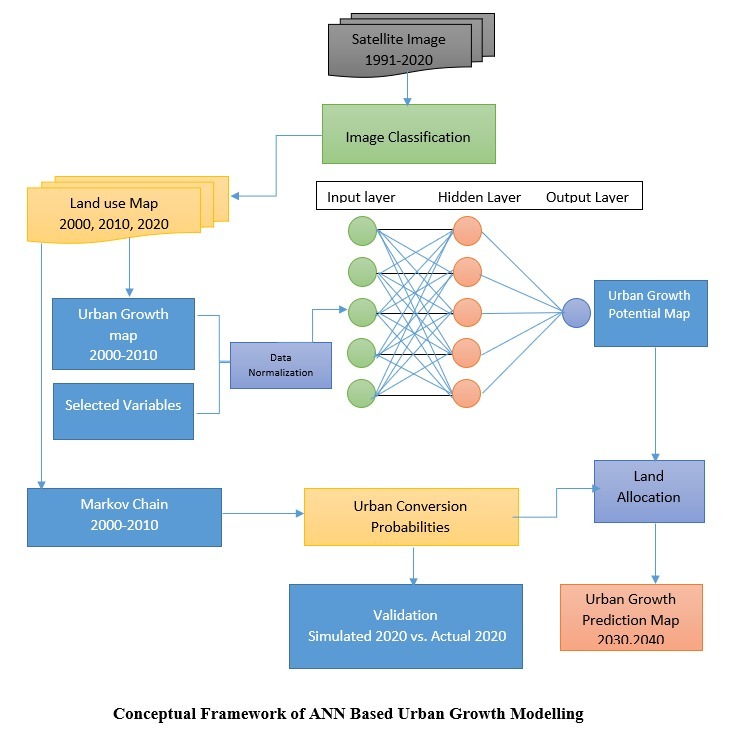
2. Modeling of Urban Growth
a. Drivers of Urban Growth
- Variable Extraction – Elevation, Slope, Aspect, Population Density, Distance from Roads, Distance from City Centers
- Remote Sensing Indices Analysis – NDVI, EVI, SAVI, NDBI, NDWI in Google Earth Engine
- Logistic Regression for Driver Variable Selection –Jamovi and TerrSet
b. Urban Growth Forecasting
- Forecasting using Cellular Automata Integrated with ANN – TerrSet
- Accuracy Assessment – Kappa Statistics
3. Urban Growth and Environmental Impact Analysis
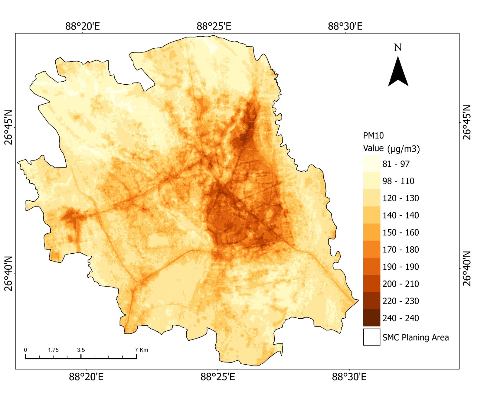
- Urban Heat Island (UHI) Analysis and Land Surface Temperature Trends – Google Earth Engine
- Urban Green Space (UGS) Change Detection – Supervised NDVI Composite Thresholding
- Green Space Fragmentation Analysis using Landscape Metrics – Fragstat, GTB Toolbox
- Assessment of Relationships between LULC and LST – Correlation and ANOVA
- Assessment of Relationships between UGS and LST – Correlation between Landscape Metrics and LST
- Advanced Analysis and Visualization of Results
- 4. Valedictory
- 1. Assignment
- 2. Visualizing and Reporting the Findings
- 3. Certificate distribution
📌 Course Highlights:
✅ Urban Landscape Exploration – LULC classification, machine learning in remote sensing, urban sprawl analysis
✅Urban Growth Modeling – Driver variable extraction, urban growth forecasting with Cellular Automata & ANN
✅ Environmental Impact Assessment – UHI analysis, green space monitoring, LST correlation studies
✅ Hands-on Training – Work on real-world datasets using GIS & Remote Sensing tools
✅ Expert Instructors – Learn from leading researchers and geospatial experts
✅ Life Time Access – continuous learning with Life time access
✅ Publication Support – Outcome based learning with Support for publication in quality journal
📌 Know Your Trainer

Dr. Apurba Sarkar is a Research Scholar at the University of Gour- Banga and serve as an Assistant Master at New Integrated Government School, Habibpur under the Department of School Education, West Bengal. He holds both an MPhil and PhD from the University of Gour Banga, with a specialization in urban environmental studies leveraging geospatial technologies. With deep expertise in remote sensing, GIS, and urban growth modeling, Dr. Sarkar blends cutting-edge research with hands-on application, driving insights into urban landscape dynamics, environmental change, and sustainable urban planning. His analytical insight and technological proficiency make him an invaluable mentor, offering a forward-thinking perspective in geospatial studies. thing you need is here.
Dr. Apurba Sarkar
🎯 Who Should Attend?
This course is designed for researchers, academicians, urban planners, and GIS professionals seeking advanced geospatial analysis skills. It is ideal for postgraduate and PhD students in geography, environmental science, and urban studies, as well as professionals in urban planning, land management, and environmental consulting. GIS and remote sensing experts looking to enhance their skills in land use classification, urban sprawl assessment, and predictive modeling will also benefit. Additionally, government officials, policymakers, and NGO professionals working in urban governance and sustainability can leverage geospatial insights for data-driven decision-making.
📢 Join Our Advanced Training Course on Geospatial Technology for Urban Environmental Analysis!
📌Why This Program
Enhanced skills
Develop a strong understanding of modeling and analyzing urban landscapes.
Practical application
Improved research capabilities
Acquire the skills and knowledge necessary to conduct Urban Growth and Urban Sprawl Analysis for research projects.
Effective interpretation and reporting
Increased publication success
Receive expert guidance on preparing and publishing analysis results in international peer-reviewed journals, increasing the likelihood of successful publication.
Professional growth and recognition
📌Training Benefits
Hands-on Learning: Gain practical skills in GIS, remote sensing, and Spatial modeling for urban analysis.
Advanced Techniques: Learn advanced urban growth modeling techniques, including Logistic Regression, Cellular Automata, and Machine Learning approaches.Environmental Impact Assessment: Understand the relationships between urban growth, green space, and environmental quality.
Data-Driven Insights: Develop the ability to interpret spatial data and derive meaningful insights for research and policy-making.
📌FAQs
What is the duration of the program?
The program is designed to be completed within 15 week, allowing participants to gain a comprehensive understanding of urban environments with the use of advanced geospatial technologies.
Is any prior knowledge of GEE and ArcGIS required to attend this program?
No, prior knowledge of GEE and ArcGIS is not required. The program starts with a comprehensive overview of the basic concepts of GEE and ArcGIS, making it accessible to participants with varying levels of familiarity with the software.
Will I have hands-on
practice with GEE and ArcGIS during the program?
Yes, the program includes
hands-on practice sessions where participants will work with real-world
datasets using GEE and ArcGIS . This practical training will enhance your understanding
and proficiency in using these software for Urban growth and sprawl analysis.
Are there any prerequisites
for attending this program?
There are no specific
prerequisites for attending this program. However, a basic understanding of
statistical concepts and research methods will be beneficial for better
comprehension of the material covered.
Will I receive a certificate upon completion of the program?
Yes, participants who successfully complete the program will receive a certificate of completion, recognizing their achievement and the skills acquired.
How will this program help me in publishing my research in international peer-reviewed journals?
This program will equip you with the necessary skills to conduct rigorous Urban Growth and Sprawling Analysis , ensuring the accuracy and reliability of your research findings. By mastering analysis of Built-up Morphology using Landscape Metrics techniques and interpreting the results effectively, you will be better positioned to prepare and publish research papers in international peer-reviewed journals.
Can I access the program materials and resources after the program ends?
Yes, participants will have continued access to the program materials and resources even after the program ends. This will allow you to review the content, reinforce your learning, and refer back to the materials when needed.
🚀 Upgrade Your Skills & Make Data-Driven Urban Planning Decisions with Geospatial Technology!