Online Training Program |
Lifetime Access
Registration is open
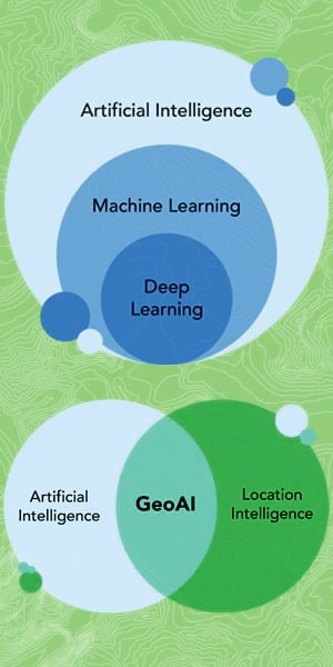
GeoAI: Transforming Geospatial Intelligence into Deployable AI Solutions
The world of geospatial analysis is rapidly evolving, shifting from static academic maps to dynamic, automated, and predictive systems that drive real-world decisions. GeoAI: Transforming Geospatial Intelligence into Deployable AI Solutions is an immersive, 14-week journey designed to transform how you interact with our planet's data.
Whether you are an academic researcher looking to scale your models, an environmental scientist wanting to harness deep learning, or a software engineer stepping into the geospatial domain, this course is built for you. We go far beyond traditional GIS. You will start with the foundations of geospatial data engineering and progress through cutting-edge techniques like Physics-Informed Neural Networks, Explainable AI, and point cloud learning.
Crucially, this course serves as an academic-to-industry bridge. You won't just build models in isolated Jupyter notebooks; you will learn to package, containerize, and deploy them. By integrating Large Language Models (LLMs), Spatial RAG, and MLOps, you will transition from building research-grade prototypes to engineering deployable, cloud-native products ready for industry use.
₹10,000 (inclusive of taxes)

A course that upgrades your research knowledge and skills into impactful publication
Resource Person
Dr. Arnab Ghosh
Dr. Arnab Ghosh is a dedicated water resources professional with a PhD in Water Resources Engineering from Jadavpur University. His core competencies lies in numerical modeling (HEC-RAS 1D/2D, MIKE 11, SWAT), field data collection (ADCP, DGPS), and employing Python/R for data analysis and predictive modeling of hydrological processes. His research, detailed in several peer-reviewed publications, quantitatively analyzes riverbank stability, bridge scouring, sediment yield, and flood inundation. As a former Senior Researcher and current Hydrology Consultant, he has successfully led and contributed to industrial and government projects concerning EIA/EMP studies, dam safety, water availability, and wetland valuation.
Who is this course for?
Geospatial Scientists and Researchers seeking advanced GeoAI skills
Graduates and Postgraduates in Geospatial Technology, seeking practical and applicable skills
Researchers aspiring to contribute to high-impact journals with their Geospatial research findings
GIS Analysts aiming to enhance their spatial analysis capabilities
Data Analysts interested in specializing in environmental data
Anyone keen on mastering GeoAI skills
Professionals in the field of Geospatial Technology eager to publish impactful research
Professionals interested to take their research-grade prototypes to deployable Industry solutions
Individuals passionate about understanding and addressing environmental changes through data-driven insights
GeoAI: Transforming Geospatial Intelligence into
Deployable AI Solutions
Course Curriculum :-
|
Class |
Main Theme |
Theoretical Part (45-50 mins) |
Practical Hands-on Part (70-75 mins) |
|
1 |
GeoAI Python Stack & Vector Data Mastery |
Introduction to GeoAI, course structure. Vector data models (points, lines, polygons). CRS fundamentals. GeoPandas, Shapely, Fiona ecosystem. |
Hands-on: Load city shapefile (Mumbai wards). Perform spatial joins (schools per ward). Reproject CRS. Visualize with matplotlib. |
|
2 |
Cloud-Native Rasters & Interactive Dashboards |
Raster data (pixels, bands, resolution). Cloud-Optimized GeoTIFFs (COGs), STAC. Rasterio & xarray. Principles of effective geospatial visualization. |
Hands-on: Clip DEM to city boundary. Calculate slope/aspect. Use stackstac to load Sentinel-2 from Planetary Computer. Build Streamlit + Folium dashboard with NDVI time-series slider. |
|
3 |
Feature Engineering & Crop Yield Prediction |
ML workflow for geospatial data. Feature extraction from rasters: NDVI, LAI, EVI. Spatial cross-validation. Green/Blue/Grey Water Footprint concepts. |
Hands-on: Extract Sentinel-2 NDVI time-series & weather data for agricultural fields. Engineer cumulative NDVI & temperature anomalies. Train XGBoost for crop yield. Calculate Green Water Footprint using SSEBop ET data. |
|
4 |
Land Cover Classification & Water Footprint Integration |
Classification algorithms (Random Forest). Blue Water Footprint: irrigation consumption from surface/groundwater. Remote sensing of irrigated areas. |
Hands-on: Land use/land cover classification to identify irrigated cropland. Estimate Blue Water Footprint by combining irrigation data with soil moisture deficits. |
|
5 |
Socio-Economic Vulnerability & Spatial Econometrics |
Integrating census data with spatial data. Tobler’s First Law, spatial weights matrices, spatial lag/error models (spreg, libpysal). |
Hands-on: Build multi-dimensional vulnerability index for flood-prone district (census + nightlights + infrastructure). Apply spatial lag model to understand poverty drivers. |
|
6 |
Flood & Landslide Susceptibility with Explainable ML |
Ensemble ML for hazard mapping: Random Forest vs. XGBoost. Topographic, hydrological, and geological conditioning factors. Hyperparameter tuning with GridSearchCV. Model evaluation: AUC‑ROC, precision‑recall for rare events. Introduction to Explainable AI: SHAP for feature attribution. |
Hands-on: Train XGBoost model for Mumbai flood susceptibility using conditioning factors (elevation, slope, distance to drainage). Generate SHAP summary and dependence plots to identify primary flood drivers. Modify the pipeline for a landslide inventory (e.g., Himalayan foothills) and interpret feature importance differences. |
|
7 |
Glacial Lake Outburst Flood (GLOF) Susceptibility & Impact |
GLOF theory: lake formation, moraine dam stability, triggers. SAR remote sensing for lake mapping: backscatter characteristics of water/snow/ice. Sentinel‑1 preprocessing for change detection. Classification of lake stability (stable vs. potentially dangerous). Downstream impact zone simulation concepts (empirical volume‑area scaling). |
Use Sentinel‑1 SAR data in Google Earth Engine or Python to delineate glacial lake boundaries in the Himalayas. Train a Random Forest classifier on morphological/geomorphometric lake features (area change, slope, distance to glacier). Overlay derived lake polygons with a simple DEM‑based flow‑routing model to visualize potential downstream inundation corridor (conceptual simulation). |
|
8 |
Deep Learning for Earth Observation – U-Net & PyTorch |
Fundamentals of CNNs. PyTorch tensors & dataloaders. U-Net architecture for semantic segmentation of satellite imagery. |
Set up PyTorch dataloader for Sentinel-2. Load pre-trained U-Net to segment building footprints or water bodies. |
|
9 |
Blue Carbon & Hyperspectral Imaging for Mineral Exploration |
Mangrove/seagrass mapping with optical+SAR. Above-ground biomass estimation. Hyperspectral data (AVIRIS/PRISMA), spectral signatures of minerals. Spectral Angle Mapper (SAM). |
Train U-Net to map Sundarbans mangroves with Sentinel-2. Estimate carbon stock. Use spectral library to identify mineral indicators in AVIRIS scene. Implement SAM classifier. Apply SHAP to CNN for band importance. |
|
10 |
Physics-Informed ML for Rainfall-Runoff & Groundwater |
Limitations of pure data-driven models. PINNs & torchphysics. Embedding mass balance into loss function. MODFLOW & FloPy introduction. Coupling PINN with MODFLOW for parameter estimation. |
Build simple PINN for rainfall-runoff prediction in small catchment. Compare with XGBoost. Set up MODFLOW model with FloPy. Use PINN to estimate hydraulic conductivity from sparse well data. |
|
11 |
Integrated Water Footprint & Scarcity Mapping |
Green, Blue, Grey Water Footprint synthesis. Grey Water Footprint: dilution needs for nitrogen from fertilizers. |
Calculate all three components for agricultural region. Estimate nitrogen loading from crop maps. Map total water footprint & identify scarcity hotspots against basin availability. |
|
12 |
Urban Microclimate, Precision Agriculture & Marine Monitoring |
Landsat thermal bands for LST. UHI modelling with ML & OSM data. Variable rate fertilization/prescription maps. Marine GeoAI: SST, chlorophyll-a, potential fishing zones. |
Generate UHI map for Delhi (Landsat 8 + osmnx). Train model to predict UHI intensity. Create nitrogen prescription map from NDVI. Process SST & chlorophyll-a for Bay of Bengal; Random Forest for fishing zones; Streamlit dashboard. |
|
13 |
Explainable AI (SHAP/LIME) & Causal GeoAI |
Advanced SHAP & LIME applications. Global vs. local explanations. XAI for regulatory compliance & stakeholder trust. Causal reasoning, DAGs, uncertainty propagation. |
Apply SHAP to crop yield model. Present feature importance plots. Compare predictive accuracy vs. decision confidence in hazard/crop models. |
|
14 |
SAR Data & Time-Series Transformers |
Synthetic Aperture Radar (SAR): backscatter, coherence, polarimetry. Pre-processing (calibration, speckle filter, terrain correction). Transformers for satellite time-series (crop classification, anomaly detection). |
Map flood extent during monsoon with Sentinel-1 (pre/post change detection). Identify obstructed roads for disaster response. Use pre-trained transformer (or build simple one with PyTorch) to classify crop types from Sentinel-2 time-series. Automate glacial lake extraction from Landsat time-series. |
|
15 |
Spatial Econometrics & Geometric Deep Learning |
SLM, SEM, spatial weights (Queen/Rook/distance). Graph theory for spatial networks. Graph Convolutional Networks (GCNs) for rivers/roads. |
PySAL/spreg spatial lag model for groundwater depletion (well density, rainfall, agriculture). Extract river network from DEM; PyTorch Geometric GCN to predict nitrate concentrations along river. |
|
16 |
Point Cloud Learning for LiDAR (Forestry & Coastal Systems) |
LiDAR for biomass, canopy height, coastal topography. PointNet/PointNet++ & semantic segmentation. |
Open3D LiDAR visualization. PointNet for ground/vegetation classification. Calculate canopy height & carbon stock (mangroves). Coastal beach profiles. |
|
17 |
Big Geospatial Data – Dask, Xarray & STAC/Pangeo |
Challenges of petabyte-scale data. Dask for parallel single-machine workflows. STAC catalogs, Pangeo cloud-native geoscience. Optical/Radar/LiDAR fusion. |
dask-geopandas + xarray with dask: monthly mean LST for entire country (chunking & parallel). Query STAC API (Planetary Computer) for Sentinel-1 & -2; stackstac + xarray to fuse optical & SAR; cloud masking with pystac-client. |
|
18 |
Distributed Computing with PySpark (GeoSpark/Sedona) |
Apache Spark, GeoSpark (Sedona), Spark GIS. Dask vs. Spark. Large-scale raster inference & vector joins. |
Local PySpark + Sedona. Large-scale spatial join (millions of GPS points to boundaries). Distributed inference for land cover classification across tiles. |
|
19 |
IoT Architecture, Protocols & Data Ingestion for Environmental Hazards |
End‑to‑end IoT system architecture: sensors, gateway, cloud broker, application. Multi‑hazard node design considerations (flood, landslide, GLOF, wildfire). Communication protocols comparison: LoRaWAN (range vs. bandwidth), NB‑IoT, 4G/5G. REST API design principles for IoT data ingestion. Introduction to MQTT for lightweight telemetry. |
Write a Python script to generate synthetic water level data (5‑min intervals) for a simulated flood sensor network. Use paho‑mqtt to publish the simulated data to a local MQTT broker (Mosquitto). Build a FastAPI endpoint (POST /sensor/reading) with Pydantic validation to receive and store the telemetry data in a lightweight database (e.g., SQLite or Redis). Write a simple Python script that acts as a mobile app sending POST requests to the API. |
|
20 |
Real‑Time Dashboards & Early Warning System (EWS) Integration |
Principles of effective real‑time geospatial dashboards. Connecting live data streams to web visualizations (WebSocket vs. polling). Alert level logic: threshold‑based vs. predictive alerts. Integrating static hazard susceptibility maps with dynamic sensor data for contextual early warning. User experience for emergency response dashboards. |
Build a Streamlit + Folium dashboard that periodically fetches sensor readings from the FastAPI endpoint (built in Class 19). Display sensor markers with color‑coded alerts based on water level thresholds (e.g., green‑yellow‑red). Overlay the flood susceptibility map from Class 6A. When a sensor triggers a high alert, highlight the predicted inundation zone from the susceptibility map on the dashboard. Run the entire stack (API, dashboard) locally to simulate a working early warning prototype. |
|
21 |
Introduction to Large Language Models (LLMs) |
Introduction to Large Language Models (LLMs) and it's applications |
- |
|
22 |
Multimodal - Large Language Models (LLMs) |
- |
Hands-on: Build a multimodal LLM chatbot, Web-based geospatial apps, UI/UX for spatial data - Streamlit, Deck.gl |
|
23 |
Introduction to Generative AI |
Theory: Overview of generative models: GANs, VAEs, and diffusion models. Transformers, How GANs work (generator vs. discriminator). Applications in GeoAI: super‑resolution of satellite imagery, data augmentation for rare events (e.g., floods, landslides), generating synthetic land cover maps, and filling clouds in optical imagery. |
- |
|
24 |
GANs for Earth Observation |
- |
Hands-on: Build a simple GAN with PyTorch to generate synthetic NDVI time‑series for data‑scarce regions. Use a pre‑trained ESRGAN model to upscale Sentinel‑2 imagery from 10m to 2.5m resolution. Explore diffusion models for cloud removal on Landsat scenes. |
|
25 |
Agentic AI |
Introduction to Agents and GeoAI Agent |
Hands-on: Build an Agent or Chat Bot |
|
26 |
Multi-Agentic AI framework |
Introduction to Multi Agentic Framework and orchestration Agent planning, execution, real-time monitoring/alerts, LangChain Agents, Collaborative roles, communication, task distribution. LangGraph |
-Hands-on: Build a multiagentic framework for Climate/Agriculture Prediction and Forecasting |
|
27 |
AI Orchestration |
Chains, tools, memory management, stateful execution, LangChain, LangGraph |
- |
|
28 |
Containerization |
The importance of containerization. Introduction to Docker. |
Hands-on: Write a Dockerfile for the FastAPI app. |
|
29 |
MLOps & API Dev |
Introduction to MLOps. Model versioning with DVC or MLflow. CI/CD for GeoAI/ Building REST APIs with FastAPI. Input/output validation using pydantic. |
Hands-on: Take the flood susceptibility model from Week 8. Package it into a FastAPI application. Create a /predict endpoint that accepts a GeoJSON point and returns the flood risk probability. |
|
30 |
Cloud Deployment, Maintenance and Upscale |
Introduction to Cloud Deployment and Its Importance |
Deploying applications on cloud platforms (AWS/GCP). Using cloud storage (S3/GCS) and serverless functions (Lambda/Cloud Functions). |
|
31 |
Introduction to Spatial RAG |
What is RAG? Types of RAGs, Geospatial RAGs. |
Hands-on: Use osmnx to create a vector database of building footprints with attributes. Use HuggingFace embeddings to create a retrieval system. Build a simple prompt that translates a user query like "find all parks within 500m of a school" into a geopandas query. |
|
32 |
Capstone Project |
|
|
How The Course Benifits You
Flexibility & convenience of time and space

A gold-standard certification signifies of excellence and reliability in a particular field
Access to expertise & world-class curriculum
Enjoyment and confidence in publication research paper
Instructors continuous support, taking your hand step-by-step to develop high-quality analysis using real data

1:1 Sessions with experts
Lifetime subscription
What's Included In The Course
- Online live classes by Dr. Arnab Ghosh
- Audio-visual cues along with each modules
- Pro tips for preparing articles
- Self-paced course with access for a lifetime and unlimited views
- Collaboration opportunity with Dr. Arnab Ghosh and Dr. Jayanta Das
- Course Completion Certificate from Advances in Geographical Research
- Downloadable study material with all the course curriculum
- Interactive Environmental Dashboards: Fully functional web-based apps built with Streamlit and Plotly that visualize time-series changes and multi-dimensional vulnerability data.
- Predictive Machine Learning Pipelines: Trained and validated models (XGBoost/Random Forest) capable of predicting crop yields, calculating water footprints, and identifying hazard drivers using Explainable AI (SHAP).
- Deployed Geospatial REST APIs: Academic models packaged into containerized (Docker) FastAPI applications, allowing end-users to send coordinates and receive real-time risk probabilities.
- Generative AI & Spatial RAG Engines: Custom-built conversational bots that use Vector Databases and LLMs to answer natural language queries based on geospatial data (e.g., "find all parks within 500m of a school").
- Simulated IoT Early Warning System: An end-to-end dashboard that ingests real-time simulated IoT sensor data, generates automated alert levels, and integrates flood susceptibility maps for disaster response.
- Industry-Standard Capstone Repository: A finalized project featuring a professional README.md, optimized code, live demos, and a comprehensive concept note for future industry extension.
Frequently Asked Questions
1. What are the prerequisites for attending this program??
The prerequisites for attending this program include a basic understanding of data analysis concepts and Python.
2. Will I need prior experience with Python to benefit from this program?
Basic knowledge of python is required.
3. Can I attend this program remotely or is it an in-person event?
This program is offered both in-person and remotely. You can choose to attend either the in-person sessions held at our designated location or participate remotely through a virtual platform. The choice is entirely up to you, ensuring flexibility and convenience in attending the program.
4. Are there any additional resources or materials provided as part of the program?
Along with the program sessions, participants will have access to additional learning resources and materials. These may include reference guides, sample datasets, and supplementary readings to further enhance understanding and practice of trend analysis in Excel, R, and ArcGIS.
5. Will I receive a certificate upon completion of the program??
Yes, upon successful completion of the program, participants will receive a certificate of completion. This certificate validates the skills and knowledge acquired during the program and can be a valuable addition to your professional credentials.
6. Can I contact the instructors or program organizers for further assistance or clarifications?
Absolutely! Our instructors and program organizers are readily available to assist participants with any questions or clarifications they may have throughout the program. You will have the opportunity to engage with them during interactive sessions, Q&A sessions, and through dedicated channels of communication provided by the program.