Online Training Program | Lifetime Access
Registration is open
HYDRO-MORPHOMETRIC CHARACTERISTICS OF THE DRAINAGE BASIN IN ARCGIS

About Certificate Course
In this online workshop and live practice, you can learn the complete process (A-Z) of morphometric analysis from scratch to production. How to download freely available data, and process data in ArcGIS environment. Moreover, you will also learn how to prepare final maps and tables for publication. The analysis of morphometric parameters gives a precise scenario of the geomorphic characteristics and the hydrological behaviour of a drainage basin, especially in the areas where hydrological data are unavailable due to the absence of a gauging station or inaccessibility to harsh topographic conditions. So, this live workshop is aimed to investigate the hydro-geomorphic characteristics of a mountainous basin. The extraction and analysis of the morphometric variables will be done using remote sensing and GIS. The morphometry of a drainage basin is a quantitative approach for evaluating the different aspects of the drainage system, viz. number, and length of the stream, drainage density, bifurcation ratio, slope, shape, and relief of the basin.
Linear properties of drainage basin viz Stream order (µ), the number of streams (Nµ), total stream length (Lµ), mean steam length (͞Lµ), stream length ratio (Rl), bifurcation ratio (Rb) and hydrological storage coefficient (Rho) will be considered for analyzing the linear characteristics of the basin.
Basin area (A), basin perimeter (P), form factor (F), circularity ratio (Rc), Lemiscate’s K, elongation ratio (Re), infiltration number (If), compactness coefficient (Cc), length of overland flow (Lg), Constant of channel maintenance, (CCM), drainage density (DD), lineament density (LD), stream frequency (Fs) and texture ratio (Tu) are the selected parameters of areal aspects analysis of the basin.
The relief aspects which consider the nature of the hydro-geomorphic behaviour of the basin incorporate total basin relief (H), relief ratio (Rh), dissection index (DI), ruggedness number (Rn), Melton ruggedness number (MRn), aspect, and average slope (Tan Ɵ) and hypsometric integral (HI) will be covered in this live workshop.
After completing this course, you will be efficiently able to prepare research articles.
Keywords: Hydro-geomorphology, DEM, Morphometric analysis, Remote sensing, GIS, Visualization, Mapping and ArcGIS
Course Curriculum
- 1. Introduction to hydro-morphologic characteristics of the drainage basin
- 2. Literature Review
- 3. Understanding of morphometric analysis
- 4. Data Sources: download DEM
- 1. How to select the study area
- 2. How to prepare a location map of the study area
- 3. How to prepare methodological flow diagram
- 4. Delineation of basin and sub-basin from DEM
- 5. Cross profile of a drainage
- 6. Long profile of a drainage
- 1. Number of streams of order µ
- 2. Total number of steams within the basin
- 3. Bifurcation ratio (Rb)
- 4. Total stream length of order µ
- 5. Mean stream length of the order
- 6. Stream length ratio (RL)
- 1. Area of the of order (Aµ)
- 2. Length of the basin of order Lbµ
- 3. Width of the basin of order µ
- 4. Basin perimeter of order
- 5. Relative perimeter (Pr)
- 6. Length area relation (Lar)
- 7. Lemniscate's (k)
- 8. Basin form factor
- 9. Basin circulatory ratio (Rc)
- 10. Compactness Coefficient (Cc)
- 11. Basin elongation ratio (Re)
- 12. Drainage density (Dd)
- 13. Stream frequency (Fs)
- 14. Infiltration Number (If)
- 15. Length of overland flow (Lg)
- 16. Constant channel maintenance
- 17. Texture ratio (Tµ)
- 1. Height of highest point on the watershed (Z)
- 2. Height on basin mouth (z)
- 3. Total basin relief (H)
- 4. Relative Relief (Rr)
- 5. Relief ratio (Rh)
- 6. Dissection Index (DI)
- 7. Ruggedness number (Rn)
- 8. Average slope (Tan Ɵ)
- 9. Melton Ruggedness Number (MRn)
- 1. Topographic Wetness Index
- 2. Topographic Position Index
- 3. Export maps
- 1. Preparation of Tables
- 2. Preparation of Figures
- 3. Preparation of final layout
Benefits of Online International Workshop
- Step-by-step procedure from data download, handling, selection, produce maps
During this workshop, participants can prepare one article related to hydro-morphometric characteristics of a drainage basin
- Instructors continuous support, taking your hand step-by-step to develop high-quality prediction maps using real data
- Live WhatsApp Chatting with instructor
- 1:1 Sessions with experts
- Life t subscription
- Any time watch recorded video

Who this course is for
Students, researchers and professionals of Natural hazards, Environmental Science, Ecology, and Geography.
Students, researchers and professionals who are interested in multi-criteria decision making and risk analysis using GIS Data.
Students, researchers and professionals who work on: Hazards, vulnerability and risk [flooding, landslides, drought], susceptibility [Groundwater potentiality, vulnerability] and Suitability [Agricultural suitability, Irrigation suitability].
Anyone interested in learning the Structured Decision-Making Using Step by Step Approach.

Dr. JaYANTA dAS
Invited Resource Person
Dr. Jayanta Das is an Assistant Professor of the Department of Geography at Rampurhat College, West Bengal. He holds a PhD from the University of North Bengal and specializes in climate change, geomorphology, hazard management, GIS/remote sensing, and sustainable agriculture. An accomplished editor and author with Springer and leading journals, he has led international collaborations, organized major conferences, and received multiple awards for his contributions to geographical research and education.
Ready to enroll live eWorkshop?
HYDRO-MORPHOMETRIC CHARACTERISTICS OF THE DRAINAGE BASIN IN ARCGIS
Certificate Course
on
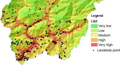
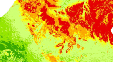
An Ensemble of Evidence Belief Function (EBF) with Frequency Ratio (FR) for GIS-based landslide prediction in ArcGIS
INR. 10000.00 USD. 115
Enroll nowCertificate Course
On
An Ensemble of Evidence Belief Function (EBF) with Frequency Ratio (FR) for GIS-based landslide prediction in ArcGIS
An Ensemble of Evidence Belief Function (EBF) with Frequency Ratio (FR) for GIS-based landslide prediction in ArcGIS
In this online workshop and live practice, you can learn the complete process (A-Z) from scratch to production. How to select parameters and why, download raster and vector data, processing data, images in ArcGIS environment, justification of variables, step by step guide of Dempster-Shafer theory of EBF and FR models, produced prediction map applying combined EBF and FR methods in Landslide prediction zonation using ArcGIS. Moreover, you will also learn validation of the susceptibility map using advanced techniques such as success rate curve and prediction rate curve.
After completing this course, you will be efficiently able to process, predict, and validate any data related to hazard, vulnerability, risk, and suitability assessment using the EBF and FR models.
Certificate Course
on
An Integrated MCDM approach for Drought Vulnerability Assessment in ArcGIS
INR. 10000.00
USD. 115
Certificate Course
On
An Integrated MCDM approach for Drought Vulnerability Assessment in ArcGIS
An Integrated MCDM approach for Drought Vulnerability Assessment in ArcGIS
In this online workshop and live practice, you can learn the complete process (A-Z) from scratch to production. How to select parameters and why, download raster and vector data, processing data, images in ArcGIS environment, justification of variables, step by step guide of SPI, CRITIC, WASPAS, and SAW models in excel, produced prediction map applying CRITIC, WASPAS, and SAW methods in Drought Vulnerability zonation using ArcGIS. Moreover, you will also learn validation of the susceptibility map using advanced techniques such as MAE, MSE, RMSE, ROC-AUC.
After completing this course, you will be efficiently able to process, predict, and validate any data related to hazard, vulnerability, risk, and suitability assessment using the CRITIC, WASPAS, and SAW models.
Certificate Course on Flood Hazards, Vulnerability and Risk Assessment using Analytical Hierarchy Process in ArcGIS
In this course, you can learn the complete process (A-Z) from scratch to production. How to select parameters and why, download raster and vector data, processing data, images in ArcGIS environment, justification of variables, step by step guide of Analytic Hierarchy Process (AHP) in excel, produced prediction map applying AHP method in hazard, vulnerability, and risk using GIS. Moreover, you can also learn sensitivity analysis in ArcGIS and validation of the susceptibility map in SPSS software.
Analytic Hierarchy Process (AHP) is the most powerful multi-criteria decision-making and Problem-Solving method first introduced by Saaty in 1980. In short, it is used for ranking the attributes to select the optimal attribute based on the hierarchical structure of goal at the top level, criteria at the second level, and alternative at third level
After completing this course, you will be efficiently able to process, predict, and validate any data related to hazard, vulnerability, risk, and suitability assessment using the Analytic Hierarchy Process (AHP).

Certificate Course
Flood Hazards, Vulnerability and Risk Assessment using Analytical Hierarchy Process in ArcGIS
INR. 10000.00
USD. 115

Certificate Course on
Groundwater potentiality and stress zonation using TOPSIS, VIKOR and EDAS models in ArcGIS
INR. 10000.00
USD. 115
Certificate Course
On
Groundwater potentiality and stress zonation using TOPSIS, VIKOR, and EDAS models in ArcGIS
In this online certificate course, you can learn the complete process (A-Z) from scratch to production. How to select parameters and why, download raster and vector data, processing data, images in ArcGIS environment, justification of variables, step by step guide of TOPSIS, VIKOR and EDAS in excel, produced prediction map applying these methods in groundwater potentiality and stress zonation using ArcGIS. Moreover, you will also learn validation of the potentiality map in ArcGIS software.