Online Training Program | Lifetime Access
Registration is open
Are you interested in gaining essential skills to assess and manage flood hazards, vulnerabilities, and risks using cutting-edge geospatial tools and techniques? Enroll in our comprehensive online course, "Flood Hazards, Vulnerability, and Risk Assessment using Analytical Hierarchy Process in Excel and ArcGIS," and take your expertise in flood risk management to the next level.
Read the Published Paper Prepared During this Course
ABOUT COURSE
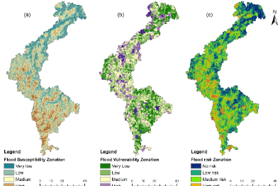
In this online certificate course, you can learn the complete process (A-Z) from scratch to production. How to select parameters and why, download raster and vector data, processing data, images in ArcGIS environment, justification of variables, step by step guide of Analytic Hierarchy Process (AHP) in excel, produced prediction map applying AHP method in flood hazard, vulnerability and risk using GIS. Moreover, you can also learn sensitivity analysis and validation of the susceptibility model in ArcGIS.
Analytic Hierarchy Process (AHP) is the most powerful multi-criteria decision-making and Problem-Solving method first introduced by Saaty in 1980. In short, it is used for ranking the attributes to select the optimal attribute based on the hierarchical structure of goal at the top level, criteria at the second level, and alternative at third level
After completing this online certificate course, you will be efficiently able to process, predict, and validate any data related to hazard, vulnerability, risk, and suitability assessment using the Analytic Hierarchy Process (AHP).
Keywords: Excel, ArcGIS, Analytical Hierarchy Process, Mapping, Prediction, Single Parameter Sensitivity Analysis, Map Removal Sensitivity Analysis
Who this course is for
Students, researchers and professionals of Natural hazards, Environmental Science, Ecology, and Geography.
Students, researchers and professionals who are interested in multi-criteria decision making and risk analysis using GIS Data.
Students, researchers and professionals who work on: Hazards, vulnerability and risk [flooding, landslides, drought], susceptibility [Groundwater potentiality, vulnerability] and Suitability [Agricultural suitability, Irrigation suitability].
Anyone interested in learning the Structured Decision-Making Using Step by Step Approach.
Are there any course requirements or prerequisites?
Basic Knowledge of Microsoft Excel
No statistical background needed
Basics knowledge in ArcGIS software and QGIS is optional
Interest in GIS prediction maps using real-life Data

Dr. JaYANTA dAS
Invited Resource Person
Dr. Jayanta Das is an Assistant Professor of the Department of Geography at Rampurhat College, West Bengal. He holds a PhD from the University of North Bengal and specializes in climate change, geomorphology, hazard management, GIS/remote sensing, and sustainable agriculture. An accomplished editor and author with Springer and leading journals, he has led international collaborations, organized major conferences, and received multiple awards for his contributions to geographical research and education.
Course Curriculum
- 1. Introduction to Multicriteria Decision Making Model
- 2. Literature Review
- 3. Understanding of susceptibility, vulnerability and risk
- 4. Analysis Criteria
- 5. Image Download: DEM
- 6. Image Download: LANDSAT 8
- 7. Data Download: OSM vector data
- 8. Data Download: Fault Lines
- 9. Data Download: Weather data
- 10. Convert IMD gridded data to CSV/Excel
- 11. Handling NetCDF file
- 12. Download: Soil map
- 13. Download: Lithology
- 1. Download: Administrative shapefile
- 2. Download: Basin shapefile
- 3. Location map preparation
- 4. Preparation of flood inventory map
- 1. Elevation
- 2. Slope
- 3. Aspect
- 4. Roughness
- 5. Topographic Position Index
- 6. Topographic Wetness Index
- 7. Stream Power Index
- 8. Sediment Transport Index
- 9. Drainage density
- 10. Long term average rainfall
- 11. Rainfall intensity
- 12. Rainfall deviation
- 13. Precipitation concentration Index
- 14. Rainfall seasonality Index
- 15. Minimum Temperature
- 16. Maximum Temperature
- 17. Evapotranspiration
- 18. Distance to Fault Lines
- 19. Distance to Streams
- 20. Distance to Roads
- 21. Land Use and Land Cover
- 22. Soil Map
- 23. Lithology Map
- 24. NDVI
- 25. NDWI
- 26. MNDWI
- 27. NDBI
- 28. BU
- 29. Population density
- 30. Female population
- 31. Total population
- 32. Road density
- 33. Distance to flood shelter
- 34. Distance to hospital
- 35. Literacy rate
- 36. Illiteracy rate
- 37. Employment rate
- 1. Data extraction
- 2. Multicollinearity analysis in SPSS
- 3. Understanding Multicollinearity results
- 1. Introduction to AHP
- 2. Steps Involved in AHP
- 3. Setting up Decision Hierarchy
- 4. Understanding Pairwise Comparison and Comparison Matrix
- 5. Priority Vector
- 6. Consistency analysis
- 7. AHP Example 1 Flood Susceptibility using Microsoft Excel
- 8. AHP Example 2: Flood Vulnerability Analysis using Microsoft Excel
- 1. Raster Data Preparation
- 2. Vector Data Preparation
- 3. Model runs
- 4. Area Calculation of each class
- 5. Export maps
- 1. Raster Data Preparation
- 2. Vector Data Preparation
- 3. Weighted Sum
- 4. Area Calculation of each class
- 5. Export maps
- 1. Model runs
- 2. Area Calculation of each class
- 3. Export maps
- 1. Map removal sensitivity analysis
- 2. Single parameter sensitivity analysis
- 1. Data preparation for model Validation
- 2. ROC analysis in ArcGIS
- 3. Data visualization in Excel
Understanding ROC and AUC results
Benefit of online Certificate Course
- Step by step procedure from data download, handling, selection, produce prediction map to validation
- Comprehensive understanding of AHP and its Interface with Various Decision-Making Interfaces
- Instructors continuous support, taking your hand step-by-step to develop high-quality prediction maps using real data
- Live WhatsApp Chatting with instructor
- 1:1 Sessions with experts
- Lifetime subscription
- Any time watch recorded video

Valedictory Session: Flood Hazards, Vulnerability and Risk Assessment using Analytical Hierarchy Process in Excel and ArcGIS
1. How to find the best journal for your manuscript?
2. How to submit the paper in a free Elsevier journal?
3. How to prepare a Manuscript, Table, Figure, Cover letter?
4. How to prepare the final output of the AHP model?
Ready to enroll Online certificate Course?
Flood Hazards, Vulnerability and Risk Assessment using Analytical Hierarchy Process in Excel and ArcGIS

Cooming Soon
Remote Sensing for Beginners
Become proficient in satellite remote sensing, spatial analysis principles, methods, applications, sensors, and GIS!
₹ 1000.00
$ 20.00
Cooming Soon
Excel Visualization
Master 50+ Excel charts, build advanced Excel visuals & learn data analysis with a top Excel instructor
₹ 500.00
$ 10.00

Cooming Soon
Prediction Mapping Using ML Algorithms
eXtreme Gradient Boosting, K Nearest Neighbour, Naïve Bayes, Random Forest for Prediction Geo-Hazards and Risk
₹ 10000.00
$ 200.00